Midwest Art

October 9, 2012

Midwest Art

017a
   We’ve been slowly making our way across the country , driving through little farming communities and past field after field of corn and soybeans. Combines are reducing the fields to stubble , stopping only to spill the dried corn kernels and soybeans into trucks headed to the grain elevators.Without a Wal Mart in sight ,the  towns are bustling as farmers buy supplies. But winter is on it’s way so what do people do out here in the heartland while they wait for spring?  They create wonderful weird art!

 OUR NEW BLOG - http://rollinginarv-wheelchairtraveling.blogspot.com/

July 30, 2012

Cape Cod , Massachusetts

031
   I’ve really been neglecting this blog! Since we left Texas we’ve been slowly meandering our way north to Pittsburgh so that we can take care of all of our once a year appointments. However we had a little free time so when the opportunity came up to join Gail , Tom and the kids on their vacation at Cape Cod we putted our way a little farther north. We had a lot of fun even though it really wasn’t warm enough for Tess to lay out on the beach! :-D  More pictures here - https://picasaweb.google.com/101444951349944784520/CapeCodMassachusettts

May 9, 2012

Dallas Arboretum & Botanical Garden

001a
   The gardens are a beautiful place to visit anytime but we happened to visit in the middle of a Dale Chihuly glass art exhibit. Dale Chihuly makes huge ,fanciful ,blown glass sculptures. Actually he’s more of designer because the blowing ,crafting and assembling is done by team of artists. Chihuly lost an eye in an automobile accident and several years later dislocated his right shoulder , making it impossible for him to hold a heavy glass blowing pipe. We’ve seen Chihuly pieces in museums , in his hometown of Tacoma ,Washington and even in a Las Vegas casino but this is the first time we’ve seen an large outdoor display. The bright , flowing shapes fit right in the garden setting resembling strange ,exotic flowers.  More pictures here - https://picasaweb.google.com/101444951349944784520/DallasArboretumBotanicalGarden

April 2, 2012

Sherwood Forest Faire in Ye Olde Texas

066
    We took a trip to England in the year 1190  and met a bunch of strange and interesting characters. ( this isn’t a reference to Chris , our sister –in-law , or our nephew , Ted or his girlfriend , Jennifer who joined us in our time travel  : D ! ).  This festival is only three years old but the two men who created the village and who oversee the project are doing a wonderful job. They’re trying to keep it as authentic as possible but are allowing a lot of fantasy ,improvising  and quirkiness so along with Robin Hood and the evil sheriff there are fairies , elves , pirates and other  unidentifiable creatures.

  More pictures here - https://picasaweb.google.com/tonyandkaren1/SherwoodForestFaire?authuser=0&feat=directlink

February 19, 2012

Battle Of Olustee Civil War Reenactment

019
   We’ve wanted to go to a Civil War reenactment for awhile but we never expected to find one in rural north Florida. One curiosity was piqued after reading the book    “Confederates in the Attic “. The author Tony Horwitz , who has had an interest in the Civil War since childhood,writes about his interactions with some hard core re-enactors and the lengths that they go to keep everything authentic.

   The Battle of Olustee was just a minor battle which didn’t affect the war at all so we figured maybe a small encampment ,a few guys shooting at each other. Wow ,were we wrong! This is a big deal in this little section of Florida. Hundreds of re-enactors set up completely authentic camps where they live in tents , cook over fires , sleep under wool blankets and feather comforters. Anything that doesn’t fit the time period must be hidden from view. All clothing is made following old patterns using appropriate natural materials. Most people take it all the way down to their underwear.

The battle seemed less authentic. Not just because nobody was actually getting killed (don’t need any more of that!) but because the fighting had to be confined to a small area so that the audience would be able to see.  The Union and Confederate armies ended up very close to each other in an open field having a shoot out. Halfway through they moved a few hundred feet so that all sections of the audience would get the full affect. And nobody died during the first half hour.

  The whole thing was a lot of fun!  More pictures here - https://picasaweb.google.com/tonyandkaren1/BattleOfOlusteeCivilWarReenactment?authuser=0&feat=directlink


January 5, 2012

Low Country in the Deep South

n
    Hope everyone had a good time over the holidays!  We meandered our way down to Florida along the coasts of North Carolina ,South Carolina and Georgia ,an area brimming over with historical sites from a pretty terrible time in US history – the antebellum period when the labor of thousands of slaves made a few people enormously wealthy.  Low Country  wealth came from an unlikely source – rice. The coast is comprised of a mixture of marshes ,lagoons ,wide rivers and swampy islands where fresh water mingles with tidal water ,an ideal place for growing rice. Rice cultivation is very labor intensive and time consuming. Getting sold down south was a dreaded occurrence for a slave who knew that it meant a life of heat , disease , never ending work and isolation. Slavery anywhere was bad enough but this was a daily hell. More pictures here - https://picasaweb.google.com/tonyandkaren1/LowCountryInTheDeepSouth?authuser=0&authkey=Gv1sRgCJGNo8HI0s-ZTg&feat=directlink

November 27, 2011

Thanksgiving in Washington DC

041
     We had a wonderful time visiting everyone in Pittsburgh and spending Thanksgiving with Tom , Gail and the kids.  We’re still stuffed – with pumpkin pie and pecan pie , turkey and dressing , cranberry sauce and mashed potatoes –yum!  Hope everyone had a good holiday !  More pictures here - https://picasaweb.google.com/tonyandkaren1/ThanksgivingInWashingtonDC?authuser=0&feat=directlink

October 25, 2011

Duluth , Minnesota

i
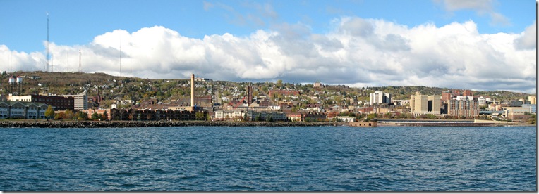
    Duluth doesn’t seem like it would be a tourist destination but an old waterfront warehouse district has been given a new life with shops,restaurants ,museums and hotels. The best part in our opinion is a four mile trail along the shoreline of Lake Superior. It’s also a good place to watch the huge tanker ships coming through the ship canal heading to the docks to pick up loads of coal ,iron ore , gravel and grain.
  Some amazing facts about Lake Superior -
1.  Lake Superior is, by surface area, the world's largest freshwater lake.
2.  The surface area of Lake Superior (31,700 square miles or 82,170 square kilometers) is greater than the combined areas of Vermont, Massachusetts, Rhode Island, Connecticut, and New Hampshire. 
3.  Lake Superior contains as much water as all the other Great Lakes combined, even throwing in two extra Lake Eries.
4.  Lake Superior contains 10% of all the earth's fresh surface water.
5.  There is enough water in Lake Superior (3,000,000,000,000,000--or 3 quadrillion-- gallons) to flood all of North and South America to a depth of one foot.
6.  The deepest point in Lake Superior (about 40 miles north of Munising, Michigan) is 1,300 feet (400 meters) below the surface.
7.  Over 300 streams and rivers empty into Lake Superior.
8,  The average elevation of Lake Superior is about 602 feet above sea level.
9.   The Lake Superior watershed region ranges in size from 160 miles inland near Wabakimi Provincial Park to only 5 miles inland from Pictured Rocks National Seashore.
10.  The Lake Superior shoreline, if straightened out, could connect Duluth and the Bahama Islands.
11.  The average underwater visibility of Lake Superior is 27 feet, making it easily the cleanest and clearest of the Great Lakes.  Underwater visibility in places reaches 100 feet.  Lake Superior has been described as "the most oligotrophic lake in the world."
12. The lake is about 350 miles (563 km) in length and 160 miles (257 km) in width.
13.  In the summer, the sun sets more than 35 minutes later on the western shore of Lake Superior than at its southeastern edge.

 More pictures here - https://picasaweb.google.com/tonyandkaren1/DuluthMinnesota?authuser=0&feat=directlink

September 28, 2011

Fall in Alaska and Canada

029
   It doesn’t last long , only a week or two , but for that short time the forests are a glow of gold and yellow aspens,birch and cottonwood against the dark green pines. Completely different from the slow turning , multicolored, hardwood fall  that we’re used to in the east but just as spectacular.
   Fall also brought an abrupt drop of ten degrees in  the temperature so we’re heading south – mostly through Canada but dropping down into the states as we get close to Pennsylvania. See all of you Pittsburghers in a month or so!  More pictures - https://picasaweb.google.com/tonyandkaren1/FallInAlaskaAndCanada?authuser=0&feat=directlink

September 11, 2011

Kenai Peninsula,Alaska

047
   Almost half of the population of Alaska lives in or near Anchorage so the Kenai Peninsula ,which juts out into the ocean just south of the city,gets a lot of visitors. This is the place to catch the big salmon that swim up the streams or take an ocean charter boat out for halibut. It’s also a good place to see glaciers and take a cruise to spot marine life.  We decided to skip that after getting so seasick the last time we tried it. : 0
 More picture here - https://picasaweb.google.com/101444951349944784520/KenaiPeninsulaAlaska

August 28, 2011

Palmer, Alaska

004 copy
   During the depression the Roosevelt administration started a program to relocate families who were living in areas with poor economic conditions. Palmer,Alaska was one of the places chosen as a new agricultural community. Most of the 203 families who moved to Palmer came from the Great Lakes states. They had been living in an area called the cut-over , a swath of clear cut forest land that wasn’t fertile enough to support their farms.

  Each family was supplied with 40 acres of land,a small house and a line of credit to buy supplies.Only about a third of them stayed past the first year but they were replaced by other families and Palmer thrives today as a farming community,supplying the rest of Alaska with vegetables.  More pictures here - https://picasaweb.google.com/tonyandkaren1/PlamerAlaska?authuser=0&authkey=Gv1sRgCKj3-YjN2a3fRQ&feat=directlink

August 18, 2011

Alaska and the Yukon

016 copy
   We made it to Alaska! It’s been a long drive through a lot of beautiful scenery. We’re a little late for tourist season and Alaska is already emptying out. Hopefully we’ll get to see everything before it gets too cold. It never did warm up so winter may come early. If it starts to snow we’re leaving!  More pictures here - https://picasaweb.google.com/tonyandkaren1/AlaskaAndTheYukon?authuser=0&authkey=Gv1sRgCMjcw9S92_O_0AE&feat=directlink

August 6, 2011

Driving to Salmon Glacier,British Columbia

FD
    Salmon Glacier is the fifth largest glacier in North America and one of the easiest to get by car. Even so it’s a pretty long trip. The jumping off point is Hyder ,Alaska which is about forty miles from the main highway and at the end of the paved road. From there it’s another twenty or more miles on a rough gravel road but it’s definitely worth the trip. The glacier is huge and the view is awe inspiring! Pictures do not do it justice.  More pictures here - https://picasaweb.google.com/tonyandkaren1/DrivingToSalmonGlacierBritishColumbia?authuser=0&authkey=Gv1sRgCJqQg-qinu_ddg&feat=directlink

July 26, 2011

British Columbia

c
     We’re finally on our way to Alaska!  We’ve been going slowly because of the weather. While the rest of North America has been baking in a heat wave ,the north west is experiencing a very wet cool spring and summer.  We wanted to avoid all of the flooding ,landslides and washouts plus British Columbia is a beautiful province to meander through rather than just rushing by on the way up to Alaska..   
     The photograph above is one of the buildings from Barkerville , a  gold mining town that is now a historic park. Most of the town dates to 1868 and it’s pretty unique ,at least to visitors from the states ,because all of the buildings are wood ,either frame construction or log.  Many US gold mining towns burnt down and were rebuilt with brick and stone.  Others were never rebuilt because  the gold had played out and any remaining buildings crumbled and decayed. More pictures here - https://picasaweb.google.com/tonyandkaren1/BritishColumbia?authkey=Gv1sRgCPSAyYG6qZyEogE

June 18, 2011

Columbia River Gorge (again)

v
   Yeah , I know – we were just here a little over a year ago but this is one of those places that we will never get tired of visiting. The scenery is so spectacular ,constantly changing with the terrain and the seasons. Plus it’s on our way to Eden and Burt’s house.Open-mouthed smile   
More pictures here - https://picasaweb.google.com/tonyandkaren1/ColumbiaRiverGorgeAgain?authkey=Gv1sRgCP3bgduUipW4Gw

June 1, 2011

Nevada’s Ghost Towns

v
   Nevada has two large cities-Las Vegas and Reno and the accompanying  suburb sprawl that has overtaken nearby smaller cities. The rest of the state is dotted with widely spaced towns. Most of them are old gold and silver mining towns slowly sinking into partial or complete ghost towns.  Very rarely did the easily mined gold and silver last for more than twenty years and then most of the miners moved onto the next big strike leaving behind equipment and buildings. Fire was also responsible for accelerating the demise of these towns so in many places the only thing left standing are sections of concrete and stone foundations and walls.  Berlin ,the one pictured above, managed to survive pretty much intact probably because at least one person was still living in the town until 1970. Kind of unbelievable to us - imagine having to drive over 100 miles to get groceries! But the night sky is incredible this far out in the middle of nowhere. More pictures here - https://picasaweb.google.com/tonyandkaren1/NevadaSGhostTowns?authkey=Gv1sRgCPSC_qnr6er1owE

May 9, 2011

Indian Country

n
     We’ve been driving through the Navajo Nation for the past several days. It’s the largest Indian reservation in the US,about the same size as the state of West Virginia. The Navajos migrated to this area of the US ,north eastern Arizona, from Canada  around 1400. They found an empty land but evidence of older settlements and a vanished people who they called the Anasazi which means ancient ones. The Anasazi are actually the ancestors of the Puebloan people  who now live in northern New Mexico.  The Navajo and all of the Puebloan tribes fared a little better than many other American Indian tribes because they were allowed to return to or stay on a portion of their ancestral lands which has resulted in a much more intact culture.
 More pictures here - https://picasaweb.google.com/tonyandkaren1/IndianCountry?authkey=Gv1sRgCMCbqL6gyMDZ4wE#

April 20, 2011

Texas Wind

k
    It’s so windy that all of the cars at Cadillac Ranch have been blown over at an angle!!  Winking smile Just kidding-they were stuck in the ground like this. It’s a public art installation where spray painting and even taking pieces of the cars is considered part of the project. More pictures here - https://picasaweb.google.com/tonyandkaren1/TexasWind?authkey=Gv1sRgCKu8isWgxqDiswE#

March 30, 2011

Texas Oil and Hurricanes

116a
    and pink spoonbills. We drove along  the Gulf coast through Mississippi and Texas passing by large areas that are still devastated from  Katrina and Rita. Most of coastal property for miles west of Biloxi,Mississippi is empty land where beautiful old houses once stood. In 2008 hurricane Ike flattened the entire little town of Gilchrist, Texas. It had been a thriving fishing,vacation and residential community spread across the narrow Bolivar Peninsula.  Many places are reverting back to a more natural state which the animals seem to be enjoying. These spoonbills were nesting in a wildlife preserve which is protected but now gets even fewer visitors because of destroyed roads and recreation areas.  More pictures here - https://picasaweb.google.com/tonyandkaren1/TexasOil?authkey=Gv1sRgCKXWtsulodmN7QE#

March 9, 2011

Mardi Gras – Mobile, Alabama

013

   We have beads! And more beads and more beads. Our  buddy , Joe, has a request in for a couple of grocery bags full but if anyone else wants some let us know otherwise they’ll be donated to Goodwill and recycled for next year’s parades.

  Celebrations start in early January  and as Lent gets closer parades get more numerous ending with the big blowout on Fat Tuesday.  We usually go to the parades for two days before we have to take a break. People who live here do it for a month or more!

  Mobile had the first Mardi Gras in America in 1703. It was part of French Louisiana and soldiers in the fort brought the tradition with them from France.  New Orleans became the capital in 1723 and quickly took over the top spot in Mardi Gras celebrations. More pictures here -  https://picasaweb.google.com/tonyandkaren1/MardiGrasMobileAlabama?authkey=Gv1sRgCMug7qmWtbX0dw#

About Me

My photo
We have been fulltiming in our motorhome since 1993. We've traveled through all 50 states and most of the Canadian provinces.It's a great life!